How do cities manage to keep water networks running smoothly despite growing demand and aging infrastructure? The answer lies in data. Specifically, in how different systems communicate and complement each other.
The integration of Esri geospatial tools with hydraulic modelling platforms is transforming that communication, giving engineers and planners the ability to visualize, simulate, and optimize water infrastructure with greater accuracy than ever before.
The Evolution of Spatial and Hydraulic Intelligence
In the past, hydraulic modelling and GIS operated as two separate worlds. Hydraulic models were used to simulate how water moves through pipes, pumps, and reservoirs, while GIS served as the mapping environment that visualized assets and topography. The gap between these systems meant teams often had to manually transfer data an error prone process that slowed down workflows and created inconsistencies in project updates.
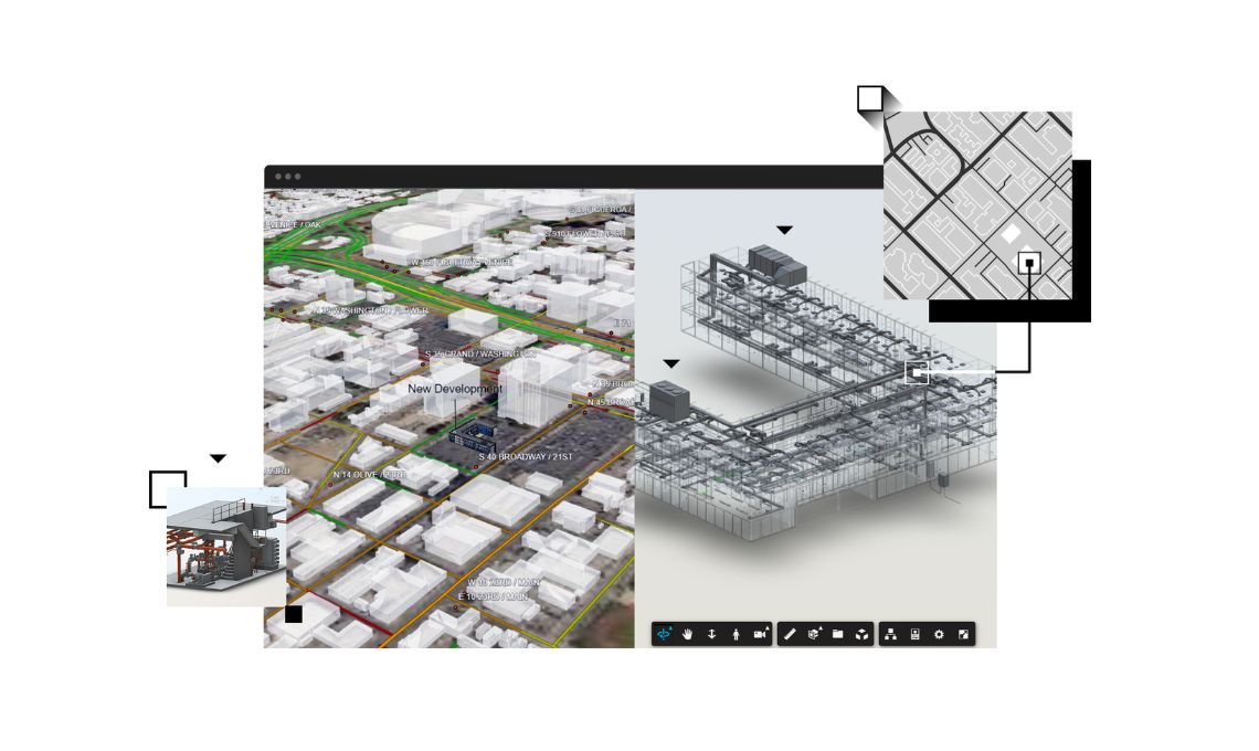
Today, this separation is fading. The latest integration between InfoWorks ICM and InfoWorks WS Pro with Esri’s geospatial environment allows engineers to bring GIS layers, if they’re web maps, shapefiles, raster images, or enterprise geodatabases, directly into hydraulic modelling projects. This means a modeler can visualize a floodplain, topographic elevation, or network layout instantly within the same workspace, reducing time spent switching between tools and formats.
A Unified Workflow: From Mapping to Modelling
The integration creates a unified environment where spatial data and hydraulic modelling operate side by side. When a GIS technician updates a pipe’s location or changes a catchment boundary, that modification can now be instantly reflected in the hydraulic model.
For instance, an engineer designing a new stormwater drainage system can overlay geospatial data showing flood zones, soil types, and existing utilities right within the modelling interface. This direct connection helps them make more accurate design decisions like determining optimal pipe diameters or identifying where runoff may exceed system capacity.
This seamless connection also improves version control and collaboration. With both systems sharing a common data backbone, project teams, if GIS analysts, civil engineers, or asset managers, can collaborate without worrying about mismatched files or outdated information.
Enhancing Decision-Making with Real-Time Context
Perhaps one of the most significant benefits of integrating GIS and hydraulic modelling is the ability to provide context-driven decision-making. Spatial data adds meaning to hydraulic outputs by showing not just how water behaves, but where and why.
For example, if a hydraulic simulation predicts a pressure drop across a neighborhood, GIS layers can immediately reveal if it’s caused by elevation changes, pipe conditions, or land use variations. Similarly, during flood modelling, integrating digital terrain models and rainfall maps helps planners visualize inundation risks in real time.
In practical terms, this kind of integration empowers cities to prioritize investments, schedule maintenance more effectively, and respond faster to system failures. It turns raw hydraulic data into actionable intelligence that supports smarter, more resilient water management strategies.
Streamlining Collaboration Across Disciplines
Water infrastructure projects are rarely handled by a single department. They typically involve planners, designers, field inspectors, environmental consultants, and operations teams. The integration of GIS and hydraulic modelling tools bridges these roles by offering a shared, visual foundation for all stakeholders.
For instance, while engineers analyze pipe hydraulics and system performance, GIS specialists can simultaneously manage spatial datasets and ensure topological accuracy. Asset managers, in turn, can use this shared model to plan maintenance schedules, track repairs, and manage risk more effectively.
This cross-disciplinary collaboration also reduces the likelihood of rework. When every stakeholder is working from the same source of truth, miscommunications decrease and project delivery becomes faster and more cost-efficient.
Building Resilient Systems with Data Integrity
Water systems are under increasing pressure from urbanization, climate change, and regulatory demands. Integrating GIS and hydraulic modelling ensures that decisions are based on reliable, up-to-date data. Since the geospatial and hydraulic components are interconnected, any network change like adding a new pump station or updating a water main, automatically updates both the map and the model.
This dynamic data synchronization preserves the integrity of the network and creates a continuous feedback loop between planning, operation, and analysis. It’s a powerful step toward achieving the digital twin concept many utilities aspire to an accurate, real-time replica of their physical infrastructure that can predict performance and optimize future designs.
A Future of Connected Water Management
The growing collaboration between Autodesk and Esri represents more than just a technical upgrade. It’s a strategic shift toward holistic water management. As tools like InfoWorks ICM and InfoWorks WS Pro continue to integrate more deeply with Esri’s ecosystem, the boundaries between mapping, modelling, and management will continue to blur.
Utilities and engineering firms that embrace this connected approach will find themselves better equipped to handle both day-to-day operations and long-term planning. From reducing data silos to enabling predictive analysis, the convergence of GIS and hydraulic modelling is shaping the next generation of water management solutions.