Civil Survey Tools

MicroCAD Civil Survey Tools
MicroCAD Productivity Toolkit for Civil 3D II is a set of essential productivity plug-ins that will make your work in Civil 3D fast, easy and efficient. These tools will dramatically reduce the number of tedious tasks and help you focus on your engineering challenges.
Civil Survey Tools includes eight sets of tools:


Top Features


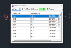
Edit Elevation Text
Function 1:
Edit numerical values by adding or subtracting an elevation difference. Works for all text and preserves the precision of values.

Radial Stakeout
Function 2:
Create a text or CAD table containing a radial stakeout of Civil 3D COGO Points. You can select Point Groups, or manually enter the point range.

Consecutive Stakeout
Function 3:
Create a text or CAD table containing a consecutive stakeout of Civil 3D Points. You can select Point Groups, or manually enter the point range.

Linework Pro
Function 4:
Draw linework between points using coordinate files with point descriptions containing linework command codes. A field to finish command without use of the Survey Database.

Alignment by Station and Directions
Function 5:
Recreate an alignment by entering stations and direction from older paper plan or records.

Polyline to Profile
Function 6:
Create an alignment, profile and profile view from a single 3D polyline.


Edit Legend – Create Legend
Function 7:
Create a legend of all used block symbols in the drawing. This keeps your legend concise and accurate, and custom descriptions can be used.
MicroCAD Autodesk Tools II is a set of essential productivity plug-ins that will make your work in Civil 3D fast, easy and efficient. These tools will dramatically reduce the number of tedious tasks and help you focus on your engineering challenges.
- Streamline your everyday tasks
- Reduce the amount of tedious work
- Become more productive
- Do things that are not possible with out-of-the-box Civil 3D
