Civil 3D 2025 brings a wave of advancements that promise to revolutionize the workflow of civil engineers. This article will delve into the key updates that include Coordinate System Modernization, Multi-baseline Corridor Setup, MMS File Saving, and the integration of Esri ArcGIS Basemaps.
Each of these enhancements aims to boost efficiency, streamline processes, and enhance design accuracy in Civil 3D projects.
Introduction to Civil 3D 2025 Enhancements
Civil 3D, a staple software for civil engineers, continually evolves to meet the dynamic demands of the industry. The 2025 update introduces several pivotal enhancements that significantly improve the software’s functionality. With a focus on efficiency and productivity, these updates are set to redefine how engineers interact with Civil 3D. Let’s explore these enhancements in detail.
Coordinate system overhaul
One of the standout features of Civil 3D 2025 is the overhaul of the coordinate system setup. This update addresses a crucial aspect of civil engineering projects by making the user interface (UI) more intuitive and easier to navigate. Here’s how the modernization benefits users:
Enhanced UI for streamlined navigation
The redesigned UI simplifies the process of setting up coordinate systems, making it more user-friendly. Engineers can now quickly set up NAVD 88 vertical datum in addition to the existing horizontal data, streamlining the setup process.
Expanded coordinate system database
Civil 3D 2025 adds more coordinate systems to its database, including customer-requested options. This expansion ensures that engineers have access to a broader range of tools, improving productivity and design accuracy.
Boosted productivity and precision
The ability to import custom coordinate systems and the overall improvements in the setup process contribute to better project outcomes. Engineers can now work more efficiently, reducing the time spent on setup and increasing focus on design.
Simplified multi-baseline corridor setup
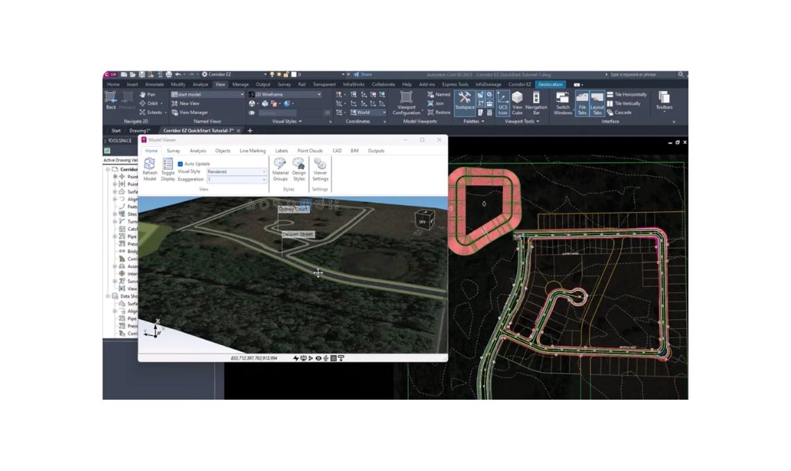
The multi-baseline corridor setup is another significant enhancement in Civil 3D 2025. This update simplifies the process of creating corridor models with multiple baselines, addressing a common challenge faced by designers.
One-Click corridor setup
Previously, setting up a corridor model with multiple baselines involved a tedious “pick and click” process. Civil 3D 2025 streamlines this by allowing designers to set up these elements with a single click, saving valuable time.
Revamped User Interface
The UI has been significantly updated to support this time-saving feature. The new interface is more intuitive, enabling designers to navigate the setup process more efficiently.
Optimized workflow efficiency
By reducing the complexity of setting up multi-baseline corridors, this enhancement improves overall workflow efficiency. Designers can now focus on refining their models rather than getting bogged down in the setup process.
MMS File management improvements
MMS (Modified Marching Squares) file saving is another area where Civil 3D 2025 brings substantial improvements. Large DWG surface files often create correspondingly large MMS files, leading to performance issues.
Efficient file saving mechanism
In previous versions, MMS files were saved every time a surface DWG file was opened or closed, even if no changes were made to the surface. This unnecessary file saving consumed additional time and processing power.
Reduced file processing time
With the 2025 update, MMS files are only saved when the surface is modified. This change significantly reduces the time required for file processing, particularly in the Autodesk Construction Cloud (ACC) environment.
Enhanced performance and speed
By optimizing the file-saving process, Civil 3D 2025 enhances overall software performance. Engineers can now work more efficiently, with less downtime spent on unnecessary file processing.
Esri ArcGIS basemaps integration
The strategic alliance between Autodesk and Esri continues to bear fruit in the Civil 3D 2025 update. The integration of Esri ArcGIS basemaps provides engineers with powerful new tools for visualization.
New Basemap Selections
Civil 3D 2025 adds five Esri basemaps to the Geolocation tab on the ribbon, including:
● Open streets
● Esri streets
● High-resolution satellite and aerial imagery
● Light grey monochrome maps
● Dark grey monochrome maps
Enhanced terrain visualization
These new basemaps help designers and engineers better visualize terrain, streets, and structures. The high-resolution imagery and detailed map options provide valuable context for projects.
Improved mapping capabilities
The integration of Esri basemaps enhances the geolocation capabilities of Civil 3D 2025. Engineers can now access more detailed and accurate mapping data, improving the precision of their designs.
Conclusion
The enhancements introduced in Civil 3D 2025 are designed to significantly improve the efficiency and productivity of civil engineers. From the overhaul of coordinate systems to the simplified multi-baseline corridor setup, each update addresses common challenges and enhances the overall user experience.
The optimized MMS file saving process reduces processing time, while the integration of Esri ArcGIS basemaps provides powerful new tools for visualization. Together, these enhancements make Civil 3D 2025 a vital update for engineers looking to stay ahead in the industry.
By leveraging these new features, professionals can streamline their workflows, improve design accuracy, and ultimately deliver better project outcomes.


