How can cities keep people moving safely and efficiently as populations grow and streets become more crowded?
Urban mobility is under constant pressure. New developments, higher traffic volumes, and changing transportation needs push city infrastructure to its limits. To respond effectively, engineers need tools that reflect real conditions and adapt as designs evolve. Autodesk Civil 3D plays a key role here by helping teams design transportation systems that are accurate, flexible, and closely connected to the realities of modern cities.
Designing transportation that reflects real conditions
From the very beginning, transportation projects depend on understanding terrain, existing infrastructure, and environmental constraints. Autodesk Civil 3D allows engineers to work with intelligent surfaces and data driven models that mirror real world conditions.
By using detailed terrain surfaces, teams can see how roads, corridors, and intersections interact with the land. Slopes, elevations, and cut and fill requirements become clear early on. This level of insight helps reduce surprises later in the project and supports designs that fit naturally into dense urban environments.
Intelligent alignments as the backbone of road design
Alignments are at the heart of transportation design. In Civil 3D, alignments are intelligent objects that guide the layout of roads, highways, and corridors.
Engineers can create horizontal and vertical alignments that respond to design standards and site constraints. When adjustments are needed, changes to an alignment automatically update connected elements. This reduces manual rework and keeps designs consistent as projects move forward.
For growing cities, this flexibility is essential. Routes often need to adapt to existing buildings, utilities, and traffic patterns, and Civil 3D makes those adjustments easier to manage.
Corridor modeling that evolves with the project
Corridors bring together alignments, profiles, and assemblies into a dynamic model of a roadway or highway. Civil 3D corridor models update automatically when any linked element changes.
This dynamic behavior allows teams to test different design options and see the impact instantly. Lane widths, medians, sidewalks, and slopes can be adjusted without rebuilding the model from scratch.
As cities plan new transport links or expand existing ones, this adaptability supports faster iteration and better informed decisions.
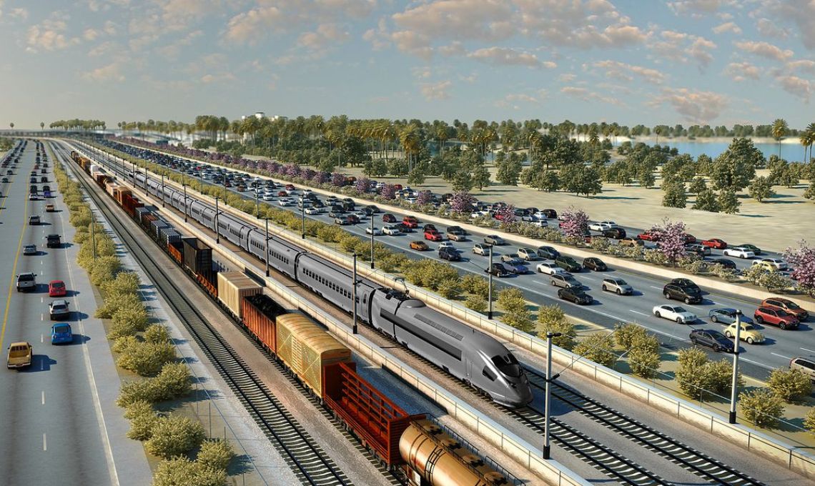
Improving traffic flow and safety
Transportation design is not just about geometry. It directly affects traffic flow and safety. Civil 3D supports the design of intersections, junctions, and complex corridors with a focus on clarity and consistency.
By visualizing how roads connect and how vehicles will move through them, engineers can identify potential issues early. Sight lines, turning radii, and lane transitions can be refined to improve safety and reduce congestion.
This proactive approach helps cities create infrastructure that works well for both drivers and pedestrians.
Integrated insight into drainage and slopes
Drainage and slope management are critical in urban transport projects. Poor drainage can lead to flooding, surface damage, and long term maintenance problems.
Civil 3D provides tools to analyze slopes, drainage patterns, and runoff behavior as part of the design process.
Engineers can see how water will move across surfaces and along corridors, allowing them to design systems that protect the roadway and surrounding areas.
This integrated insight supports more resilient infrastructure that can handle heavy rainfall and changing climate conditions.
Reducing manual work through connected design
One of the biggest advantages of Civil 3D is how it links every design element. Profiles, surfaces, alignments, and corridors are all connected. When one element changes, the entire model updates automatically.
This reduces the need for repetitive manual adjustments and lowers the risk of inconsistencies. Teams spend less time correcting errors and more time improving the design.
For cities managing multiple projects at once, this efficiency can make a significant difference in delivery timelines.
Supporting long term urban resilience
Transportation infrastructure must serve cities for decades. Civil 3D helps planners and engineers think beyond immediate needs by providing a clear view of how designs will perform over time.
Accurate modeling of slopes, materials, and drainage supports more durable construction. Clear documentation and coordinated models also make future upgrades and maintenance easier.
By designing with long term resilience in mind, cities can expand their transportation networks without compromising safety or performance.
A smarter approach to urban mobility
As cities grow, the demand for smarter, more connected transportation systems will continue to rise. Autodesk Civil 3D gives engineers the tools to respond with designs that are accurate, adaptable, and closely aligned with real world conditions.
From intelligent alignments to dynamic corridor models and integrated drainage analysis, Civil 3D supports a holistic approach to transport design that benefits both planners and the communities they serve.